
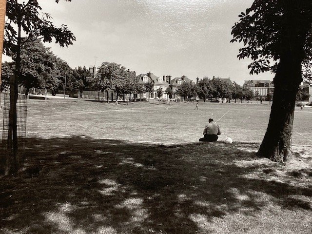
See what Tollington looked like in the 60’s & 70’s
Islington North may seem quite lovely today, but it wasn’t so long ago that it was a different place. Heavily bombed during World War 2, it wasn’t until the late Sixties that any real investment began going into the neighbourhoods after the destruction of war.
Below you’ll find an archive of images of Islington in the late ’60’s to mid-’70’s. Read more under the image collection to find out more about local history and the formation of the park.
If you have more images of the local area through the ages, stories you want to share, or just want to get involved in the work we do to make the park a more beautiful place to be, click this link to join the group.
You can also join our regular annual festival or donate to our work!
A Rare Collection
Leslie William Blake took a huge number of images of the local area to support his case, creating an invaluable archive of incredibly rare images when he did – some of which we were able to put on show here, thanks to Joanna, who had scans of some of these images in her possession.
The following archive should be of interest to anyone who wants to get some sense of what our neighbourhood looked like back then.
At the end of the collection you’ll also see two pictures taken at a street party that took place on Wray Crescent to celebrate the Coronation of Queen Elizabeth II.
Click the pictures to make them larger and easier to see.


The images were captured by Leslie William Blake when local campaigners and the Tollington Park Action Group began to fight to preserve some of the buildings, including the creation of the local conservation zone.
Wray park didn’t exist until the seventies.
The History of Tollington
Humans have lived in this area since the Stone Age. Once part of the Great Forest of Middlesex, Tollington was at one point settled by Vikings. It later became part of the Anglo-Saxon manor of ‘Tollandune’, meaning Tolla’s Hill or Pasture. By the time of the Domesday Survey, Ranulf, brother of Ralph Ilger, held two hides of land (probably around 200-acres) here.
Hornsey Road was part of the old road to Whetstone via Crouch End. There was a Barton’s Farm in Tollington Lane in 1557 and a Tollington Farm between 1701 to 1820. At that time the area connected to Holloway by Roffe’s Lane, which became Tollington Way.
Once upon a time, this was all fields
Islington had extensive pastureland – in Tudor times it was known as “Cow Town”, and apprentices on days out flocked to the area to eat cream and gooseberries. That’s why the area around Wray Crescent was used to pasture dairy herds, probably run by Welsh dairy farmer Richard Laycock. His massive farm, the “largest in the kingdom”, spanned Hornsey Road, Liverpool Road, and Upper Street.
At that time, milkmaids pushed trolleys, or drove cows, to sell milk in the City of London. The Welsh influence remained strong, the last Welsh dairy in Islington closed in 2001. When the railways came they made it possible to move milk across the country fast, so fields gave way to streets as the population exploded in the Victorian age. By 1900, Islington’s population hit 350,000+, up from c. 10,000 in 1800.
The pretty villas erected in the Italian style along Tollington Park were among the earliest in North Islington. By 1870 you’d be drinking at the Park Tavern, The Plough or the Crown Inn, which were among oldest local pubs, perhaps enjoying piano music from the piano factory in Leeds Place, or bread baked at Price’s large bakery at Pine Grove.
What about the park?
As we mentioned, Wray Crescent park didn’t actually exist until the mid-70’s.
Wray Crescent street development really began around 1870 with a second wave a decade later. The biggest school, Tollington Park College, now Islington Arts & Media School, was built in 1852. Also once known as George Orwell School it ironically became one of the first UK schools with CCTV, local gossip claims. Renowned photo-journalist, Sir Don McCullen attended the school there.
In the seventies much of the area remained dilapidated, which is why a number of buildings were knocked down to create the space that became Wray Crescent park. Tollington was a poor, working class area, with a big population of Welsh, Irish, Jamaican, and others from all over the world.
By the mid-70’s, Islington understood that the area needed more access to public green space. We still do — Islington still has less green space than any other borough in the UK.
Fascinating insight into the local area! Hadn’t realised quite how many houses and complete streets were knocked down! Many thanks for posting such interesting historical information about the Wray Crescent, Tollington and Finsbury Park area!
One item missing is the importance of the arrival of the railway which allowed commuting and was one of the reasons for the huge increase in inhabitants in the area. The pub on the corner of Hanley and Hornsey was called the Railway.. Also you can still see traces of the use of horses for private and public transport. Before 74 TollingtonPark was built a track ran down the side of 72 to stables. Before that where nos 72-64 are now there used to be an orchard. Those houses were built around 1853. I think they were speculative build because ours at least was rented out – nice starter homes. St Marks church was built first
Hah – ironically, the railway also had the effect of making it possible to move milk longer distances which is why cattle moved out and people moved in. Prior to this the dairies of islington served the city of London (as the UK is basically all built to serve the interests of the city of London and still does), with milk maids pushing trolleys of the stuff into London from the dairies here. The arrival of the train meant the dairy farmers became property developers!